1
Spatial Planning
Protects the Landscape
Kindly supported by SRG and cinémathèque suisse.
Place: Glattal, Canton of Zurich; Olten
Interviews: Wilhelm Natrup, Chief Planner Canton of Zurich
Jörg Amsler, Federal Office for Agriculture, Bern
Spatial planning devises the rules of the game that govern the design of living space. In order to implement these, planning needs effective tools, for example, the possibility to reduce or limit residential areas and even transfer building zones from one location to another. The landscape should be kept free of any construction.
Completely undeveloped areas are rare in Central Switzerland. A lot of open countryside has been built upon. Taking advantage of the landscape is not just about enjoying the view and relaxing outdoors. Our landscape is also a prerequisite for food production. It is a living space for animals and plants. It ensures we have clean water and fresh air. We need open landscape to live. The classification of building zones and non-building zones is one of the fundamental principles of spatial planning in Switzerland. Many communities want to extend their building zones, despite the fact that one quarter of existing building zones in Switzerland are yet to be developed. Some of these building lots are not available because the owners do not want to sell, while other lots are available, but are in areas where there is a lack of demand. Furthermore, there are built-up areas that still have capacity for new development in terms of living and working space. At present, Switzerland does not need new building zones; in actual fact, the current building zone portfolio is in need of reorganization and efficient utilization. The goal of spatial planning is to protect the landscape and further develop existing settlements through good design and improved functionality in order to provide us, and future generations, with the best possible quality of life. We are not trying to build a new Switzerland; rather we are redesigning the country’s existing settlements. Hence, spatial planning turns sprawl into settlements.
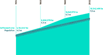
Growth of Settlement Area and Population
Glattalbahn
Die Glattalbahn ist ein Schlüsselprojekt, um das Agglomerationsgebiet Zürich Nord/Mittleres Glattal zu einer Stadtlandschaft von hoher urbaner Qualität zu entwickeln.
Amt für Raumentwicklung Kanton Zürich
Die Schweiz aus der Vogelschau
Ein Land in Bilderrätseln
Christoph Ruckstuhl, Paul Schneeberger
Zürich, NZZ Libro, 2011
Städtische Dichte
Avenir Suisse (Hrsg.), NSL (Hrsg.), Vittorio Magnago Lampugnani (Hrsg.), Thomas K. Keller (Hrsg.), Benjamin Buser (Hrsg.)
Zürich, NZZ Libro, 2007